A cliff-edge Inca complex on Day 3 whose name is often glossed “inaccessible town.” Steep stairs, exposure, and some of the trail’s best drama.
What is Sayacmarca?
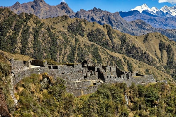
Sayacmarca (also Sayaqmarca / Sayaqmarka) is one of the most dramatically sited ruins on the classic Inca Trail. The Quechua name is commonly glossed as “inaccessible town” or a steep-place town — a fair description once you see the promontory, cliff drops, and single steep approach.
Our tour data places the stop near 11,852 ft (3,612 m). Popular guides often round the complex to about 3,600 m. It sits on Day 3, after the Runkurakay sector and before the Phuyupatamarca / cloud-forest descent toward Camp 3.
Why it feels inaccessible
The site occupies a narrow mountain crest with exposure on multiple sides. Entry is typically via a steep stone staircase cut into the hillside (trek write-ups often mention on the order of ~90–100 steps — treat exact counts as popular figures, not a lab measurement). Inside, corridors and terraces thread between buildings with serious drop-offs beyond the walls.
What you’ll see
- Approach stairs and gate-like access into the complex
- Ceremonial and residential zones described by guides as a compact “citadel” layout
- Narrow passages, plazas, and viewpoint edges over deep valleys
- Clear evidence of why the Inca road system needed control points and rest infrastructure, not only temples
Function is interpreted variously (checkpoint, administrative outpost, agricultural support). Without a primary excavation citation on hand, we describe what hikers can observe and how the site sits in the trail sequence rather than inventing a single official purpose.
#sayaqmarca (note spelling variant vs the URL slug sayacmarca).
Practical tips
- Watch footing on the entry stairs — exposure is real.
- Stay inside guided paths; do not edge-walk for photos.
- Morning light is often clearer than afternoon cloud build-up.
- Poles may need stowing on the steepest stone.
- Carry a wind layer; ridge ruins run colder than forest camps.
Notes on sources
Trail placement and “inaccessible” naming are consistent across operator and general Inca Trail references. Building-by-building interpretation varies; this page stays conservative on archaeology.