Warmiwañusqa — the high saddle on Day 2 of the classic Inca Trail — is where thin air, steep stone, and huge Andean views collide. Here is what the pass is, why it is hard, and how to face it.
What is Dead Woman's Pass?
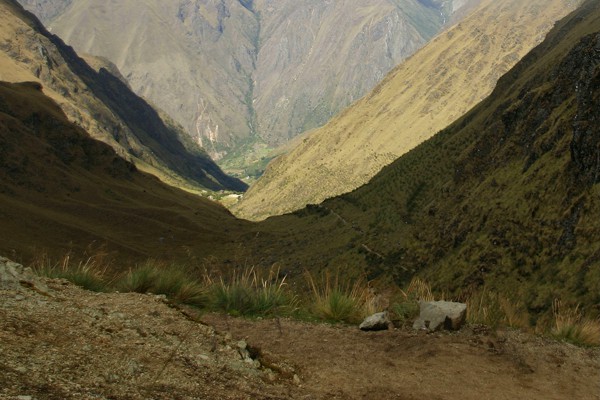
Dead Woman's Pass — Warmiwañusqa or Warmi Wañusqa in Quechua (also Warmiwanusca / Abra Warmiwanusca; Spanish Paso de la Mujer Muerta) — is the highest point on the classic 4-day Inca Trail to Machu Picchu. Our on-trail Garmin GPSMAP 62 track places the crest at about 13,800 ft (4,206 m). Operator and guidebook figures commonly list ~4,215 m (about 13,828–13,829 ft). Treat that spread as normal: units, datums, and exact saddle points differ. On this site we lead with our logged GPS figure and note the published range.
In the standard itinerary this is the climax of Day 2: a long climb from Camp 1 at Wayllabamba through cloud forest into alpine grassland, then a steep descent toward Camp 2 in the Pakaymayu valley.
How the pass got its name
Two explanations circulate among guides and trekkers:
- Silhouette theory (most common): From below, the ridgeline can look like a woman lying on her back — head, chest, and feet formed by the mountains.
- Literal / legendary readings: Some tellings connect the Quechua name (“dead woman”) to stories of hardship at altitude. Treat these as oral tradition unless a primary historical source is cited.
What is not in dispute is the pass’s reputation: for many hikers it is the hardest single effort of the trek.
Why Day 2 feels so hard
From Wayllabamba (or alternate high camps such as Ayapata on some itineraries) you gain on the order of 1,000+ vertical meters in thin air — often summarized as roughly 3,000–4,000 feet of climbing depending on exact camp pairing. Day 2 is widely called the hardest day of the classic trek for that reason.
- Distance often on the order of ~11 km / ~7 miles (camp-dependent; do not treat any single blog number as universal)
- Time on trail commonly 6–7+ hours with breaks
- Ascent to the saddle often 4–5+ hours from the morning camp
- After the crest: steep descent toward Pacaymayo / Pakaymayu camp near ~3,600 m
Above the treeline the environment shifts to open tundra: sun, wind, and cold can hit hard even when Cusco felt mild. Porters and cooks usually move faster; hikers should plan a steady pace rather than racing the group.
#dead-women-pass.
Altitude: what to expect
At ~4,200 m, available oxygen is substantially lower than at sea level (often summarized as roughly 40% less O₂ pressure than sea level — a rule of thumb, not a personal medical measurement). Cusco itself sits near 3,400 m; the pass is still a step higher than the city.
- Spend 2–3 nights acclimatizing in the Sacred Valley / Cusco before Day 1 when you can.
- Go slower than your ego wants on the final push to the saddle.
- Drink water, eat snacks, and tell your guide early if you have severe headache, confusion, or breathlessness at rest.
- Medication such as acetazolamide is a personal medical decision — discuss with a clinician before the trip.
At the top — and the descent
The saddle is exposed. On a clear day you get wide Andean views; in cloud you may only see the next cairn. There is rarely a long picnic at the crest — wind and schedule push groups over and down.
The descent toward Pakaymayu (Camp 2) is steep stone steps that punish quads and knees. Trekking poles help. Camp 2 sits much lower (our data: about 11,781 ft / 3,590 m), which often feels like a relief after the pass even though you are still high.
Practical tips for Dead Woman's Pass
- Break the climb into landmarks (forest → Llulluchapampa area → switchbacks → saddle) instead of staring at the skyline.
- Layer system: cold start, hot climb, freezing wind on top — keep a shell accessible.
- Sun protection is serious above treeline (hat, SPF, sunglasses).
- Do not compare your split times to porters or fitter hikers.
- If your group offers a horse or emergency support options, know the plan before you need it.
- Celebrate briefly, then protect your knees on the way down.
Notes on sources
Elevation and Day 2 logistics are cross-checked against common trek references and our Garmin track. Published crest heights often cluster near 4,215 m; our page leads with the site GPS high point (~13,800 ft / 4,206 m). Naming folklore is presented as guide tradition, not archival proof.
Explore it in the 3D tour
The flyover makes the scale obvious: the long climb from Camp 1, the narrow crest, and the drop into Pakaymayu. Use it to preview Day 2 before you book — or to relive the pass afterward.